3. Data types
3.1. Overview
pgSphere provides spherical data types for storing with PostgreSQL. Furthermore, there is a data type to do transformations.
3.2. Point
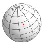
sites on earth
star positions on the sky sphere
spherical positions on planets
A spherical point (or position) is given by two values: longitude and latitude. Longitude is a floating point value between 0 and 2π. Latitude is a floating point value, too, but between -π/2 and π/2. It is possible to give a spherical position in degrees (DEG) or with a triple value of degrees, minutes and seconds (DMS). Degrees and minutes are integer values. The seconds are represented using a floating point value. A fourth method is specifying a longitude value as a triple value of hours, minutes and seconds (HMS). But, you can not use it with latitude values.
Example 1. A position specified using longitude and latitude in radians
sql> SELECT spoint '(0.1,-0.2)';
Example 2. A position specified using longitude and latitude in degrees
sql> SELECT spoint '( 10.1d, -90d)';
Example 3. A position specified using longitude and latitude (DMS)
sql> SELECT spoint '( 10d 12m 11.3s, -13d 14m)';
Example 4. A position specified using longitude in HMS, and latitude in RAD
sql> SELECT spoint '( 23h 44m 10s, -1.4321 )';
As you can see you can combine the input format for longitude and latitude. The value pairs are always enclosed within braces. Spaces are optional.
3.3. Euler transformation
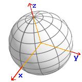
spherical object transformations
spherical coordinates transformations
The input syntax of an Euler transformation is:
angle1, angle2, angle3 [, axes ]
where axes is an optional 3 letter code
with letters : X, Y, or
Z. Default is ZXZ.
angleN is any valid angle with the input
format RAD, DEG, or
DMS.
To do a transformation, you have to use a transformation operator (see Section 5.10).
3.4. Circle
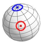
sites on earth having a maximum distance from another site
round cluster or nebula on sky sphere
a position with an undirected position error
A circle is specified using a spherical point (spoint) and a radius :
< point , radius >
Valid radius units are RAD, DEG, and DMS. The circle radius must be less than or equal to 90° and cannot be less than zero.
3.5. Line
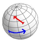
direct connection of two points
meteors on the sky sphere
To allow lines with a length larger than 180°, the input i syntax is a somewhat complex.
A general located line with a length
length is defined as a line starting at
position (0d,0d) and ending at position
(length,0d) transformed with an Euler
transformation euler. The input syntax
is :
( euler ), length
Note:
For a simpler line input, use casting operators (Section 5.1) or constructor functions (Section 4).
If the length is larger than 360°, the line length is truncated to 360°.
The transformation
eulerwill always be converted to an Euler transformation using axes Z, X, and Z.
3.6. Ellipses
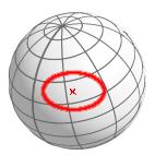
If the center of any spherical ellipse is the North Pole, the perpendicular projection into the x-y-plane gives an ellipse as in two-dimensional space.
Use cases are:
cluster or nebula on the sky sphere where the `height' is lower than the `width'
to describe a position error
An ellipse always has:
a major radius
rad_1a minor radius
rad_2a center
centera position angle
pos(inclination)
Hence, the input syntax is:
< { rad_1, rad_2 }, center, pos >Note:
The radii
rad_1andrad_2have to be less than 90°.If
rad_1is less thanrad_2, the values will be swapped.The position angle
posis defined within pgSphere as a counterclockwise rotation around the ellipse center and is zero, if the ellipse is “parallel to the equator”
3.7. Path
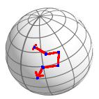
rivers on earth
trajectories of planets or comets on the sky plane
Paths within pgSphere are simplified lists of positions. The input syntax is :
{pos1,pos2[,pos3[,pos4[,...]]]}Note:
The distance between 2 sequent positions has to be less than 180° and greater than zero.
At least 2 positions are required.
3.8. Polygon
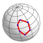
A spherical polygon is a closed spherical path where line segments cannot be crossed. One main use case are areas on the earth and sky sphere. Polygons within pgSphere have the same input syntax as paths:
{pos1,pos2,pos3[,pos4[,... ]]}Note:
A spherical polygon has the same restrictions as a spherical path (see Section 3.7). Except that a polygon needs at least 3 positions.
The line segments can not be crossed.
The maximum dimension of a polygon must be less than 180°.
3.9. Coordinates range
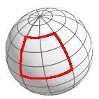
A spherical box is a
coordinates range. Hence, you can select objects within a
longitude range and latitude range. The box is represented
using two spherical points: the southwest
(pos_sw) and the northeast
(pos_ne) edge of the box. The input
syntax is:
( pos_sw, pos_ne )
or
pos_sw, pos_ne
Note:
If the latitude of the southwest edge is larger than the latitude of the northeast edge, pgSphere swaps the edges.
If the longitude of the southwest edge is equal to the longitude of the northeast edge, pgSphere assumes a full latitude range, except that the latitudes are equal, too.
3.10. smoc: HEALPix Multi-Order Coverage map
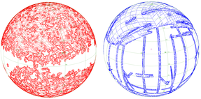
The datatype smoc allows one to define and manipulate any region of the sky in such a way that basic operations like union, intersection can be performed very efficiently. It is dedicated to VO applications or VO data servers for building efficient procedures for which mapping knowledge is required like generic catalog cross-match, computation of data set intersections, etc. This encoding method is called "Multi-Order Coverage map" or "MOC".
The goal behind the MOC is to get a spherical geometry description for any sky region in order to provide very fast and accurate union, intersection and equality operations between them. In order to accomplish this task, we based the system on a regular and hierarchical partitioning of the sphere, a process called tessellation, yielding pixels of different size. At level 0, the sky is divided into 12 pixels numbered 0 to 11. At the maximally defined level 29, there are 12 * 4^29 = 3458764513820540928 pixels.
The MOC standard is described at http://www.ivoa.net/documents/MOC/
level/pixel1-pixel2 [...] level/pixel1-pixel2 [...]